Hidden Green: the Stories Buried Beneath Burnaby Parks
Most people who visit Burnaby's parks go to the same places. Deer Lake for the views, Central Park for the trails, Burnaby Mountain for the sunset. These are fine parks, well-maintained and well-loved. But they're not where the stories are.
The stories are in the smaller parks, the ones you pass without noticing, the ones named after streets or families nobody remembers. Burnaby maintains over 160 parks across more than a quarter of its land, and most of them sit quiet, holding histories that never made it onto plaques. A beaver pond that real estate promoters tried to rename. A garbage dump where children now dig for buried treasure. A cenotaph built by a stonemason who fought in the war it commemorates. Nineteen years of municipal service reduced to a street sign.
These four parks won't take your breath away. But if you walk them with the right questions, they'll tell you what Burnaby was before it became what it is.
You had to squint to see it
Across from the Greystone Shopping Mall, at the base of Burnaby Mountain, a trail leads away from the parking lot into unexpectedly dense forest. This is Squint Lake Park, a place whose name is itself a century-old joke.
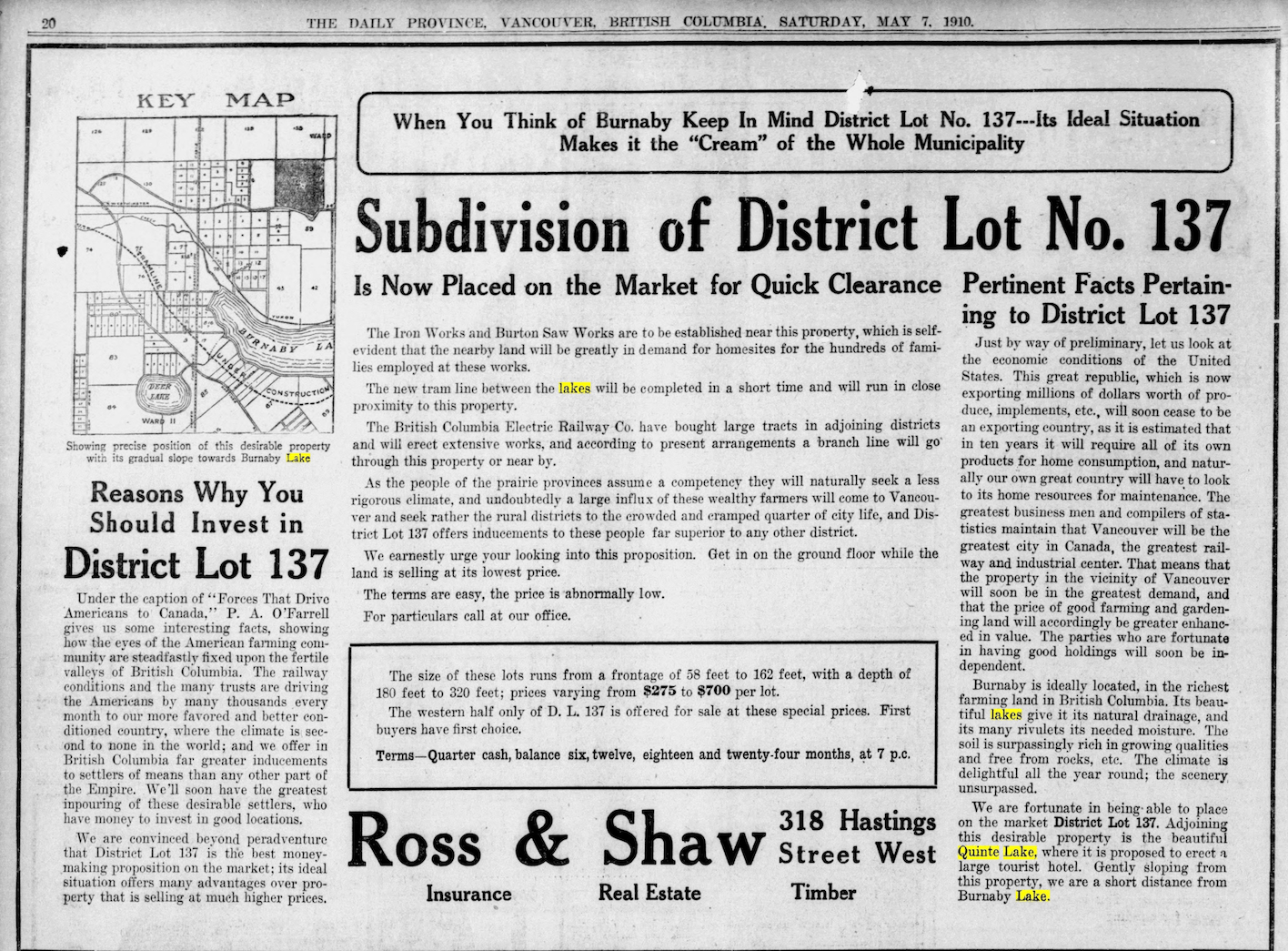
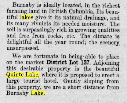
In 1910, Vancouver real estate firm Ross and Shaw placed an advertisement in the Daily Province for a new subdivision on the slopes of Burnaby Mountain. The ad promised buyers proximity to "the beautiful Quinte Lake, where it is proposed to erect a tourist hotel." Residents of the old Lochdale district must have laughed out loud. The "lake" was a beaver pond in a marsh, so modest that locals joked you had to squint to see it. The grand name never caught on. The joke stuck forever.
Lochdale in those years was absorbing waves of European immigrants. For these families, the beaver pond became something like an open-air community centre: swimming in summer, and in winter, when the water froze solid, people came from miles around to skate. Then development arrived, the swamp was drained, the pond vanished. The park today is a monument to what's no longer there.
But beneath your feet, more than memory remains. Prehistoric fossils have been found in this mud. In 1920, the largest skeletal remains of a duck ever discovered here were excavated, still stored at the Royal BC Museum. The park also holds Burnaby's largest sedimentary rock, left behind by the last ice age. And at the southern edge, there's a detail no one has explained: an underground chute about four feet in diameter that has never been traced to its source. It simply disappears into the earth.
The nearly two-kilometre trail loops around the city-run golf course, passing through wet margins where skunk cabbage and sword fern grow thick. Near the entrance stand metal-framed sculptures of bears covered in living plants, slightly strange, slightly magical. Eagle Creek, fed by the mountain's watershed, flows through the park toward Burnaby Lake. Volunteers with the Eagle Creek Streamkeepers still monitor the salmon that return here.
It's one of the most atmospheric walks in the city, a place where developer ambition met local wit, and the locals won.
Getting there: Phillips Avenue at Woodbrook Place, across from Greystone Shopping Mall. Easy loop trail with minimal elevation change.
From landfill to playground
There's a park in southeast Burnaby where children dig in sandboxes for buried artifacts. The artifacts are replicas, a tin can, a doll, a baseball, an apple core, cast in resin and concrete. But they're faithful reproductions of actual items pulled from the ground beneath their feet. Because for most of the twentieth century, this wasn't a park. It was a garbage dump.
Taylor Park represents one of Burnaby's most unlikely transformations. The land started receiving refuse as early as 1910, when the headwaters of Jerry Rogers Creek became an informal dump. By 1964, all of Burnaby's garbage was destined for what became the Stride Avenue Landfill. The gully filled until 1969. Then came decades of contamination, methane management, and slow remediation.
The park finally opened in fall 2005, named after a family that had nothing to do with garbage and everything to do with community. The Taylors arrived from Winnipeg in the late 1930s and became pillars of Burnaby youth sports. The father coached and managed soccer teams; his sons followed as players, coaches, managers, referees. In the 1960s, the family helped launch one of the first young women's soccer leagues in the Lower Mainland. Their legacy is hundreds of weekend mornings on pitches across the city.
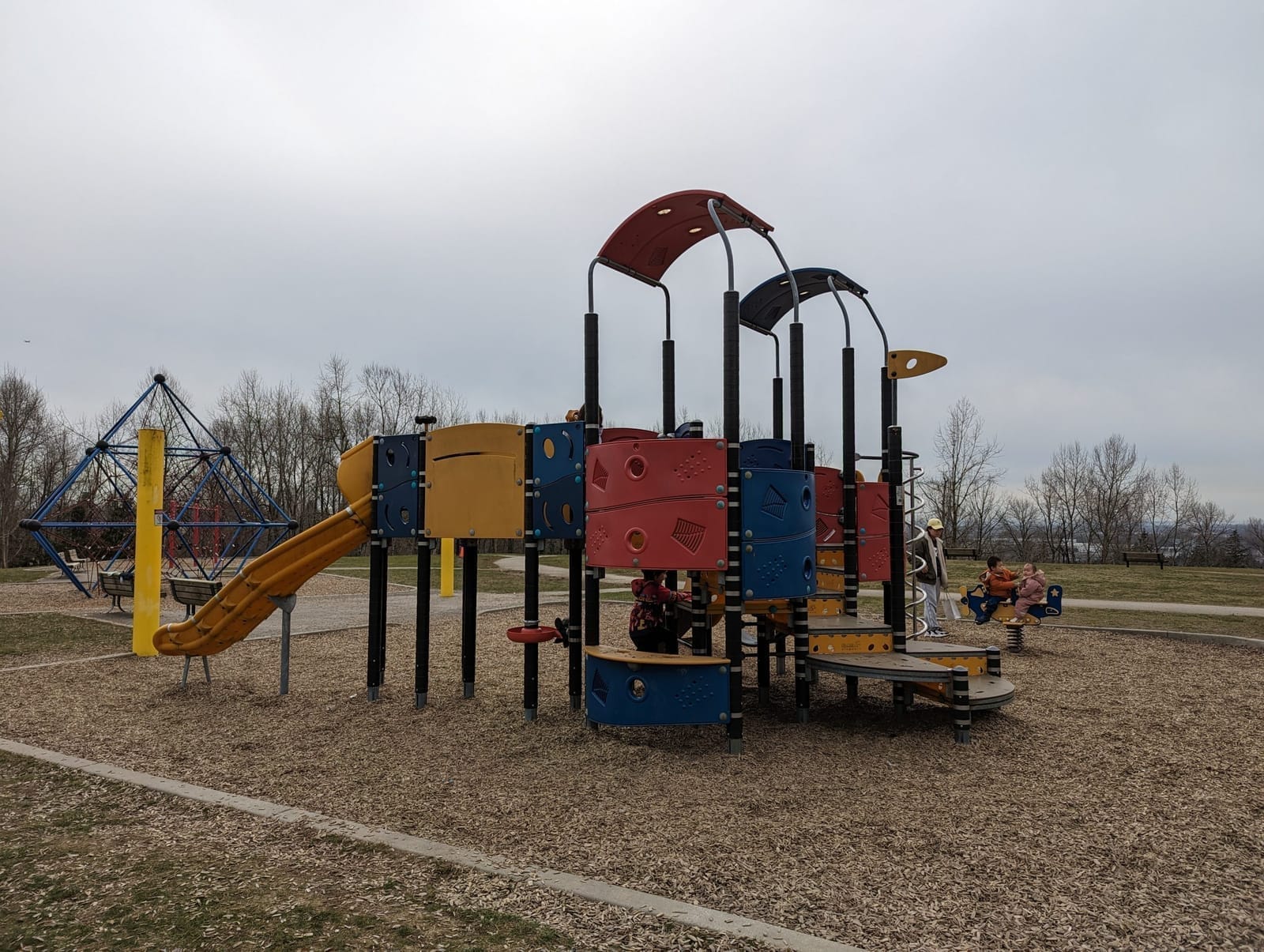
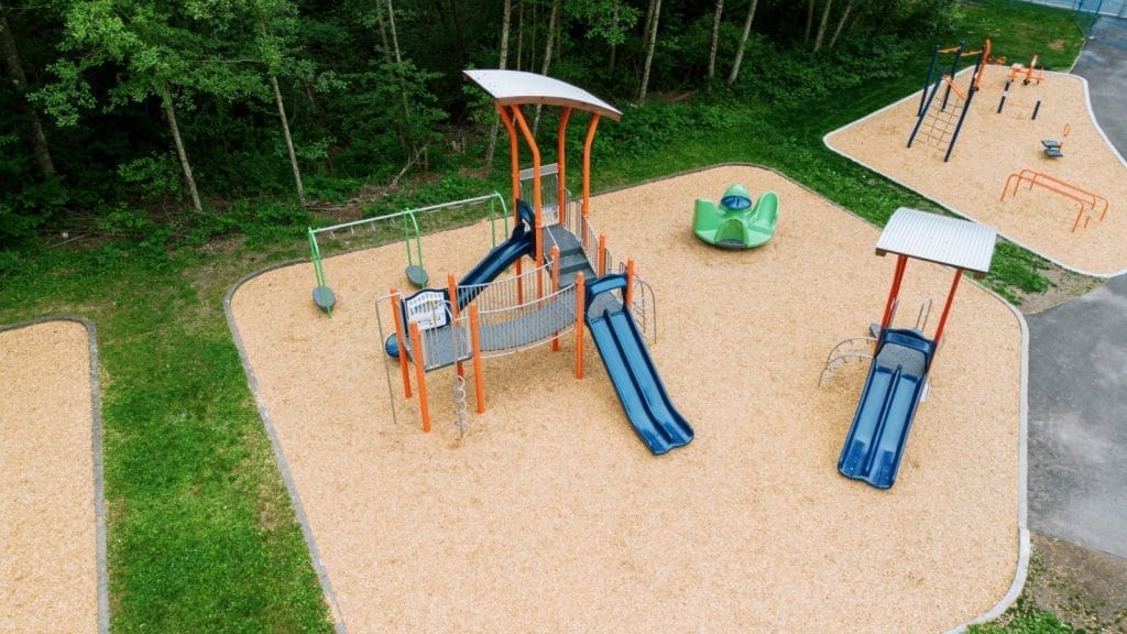
The park's designers made a remarkable choice: instead of erasing the landfill history, they embraced it. The archaeological sandbox invites children to discover the past literally underfoot. An art tower houses actual artifacts from the dump years, displayed alongside toys donated by students at the adjacent elementary school. A mosaic picnic table was designed by local high school art classes. The youth area, bike skills course, basketball court, disc swing, ball hockey — was shaped by direct input from neighbourhood teenagers.
Today the park covers roughly 27 acres near Edmonds SkyTrain, bordered by the BC Parkway, Metro Vancouver's original recreational cycling route. A large off-leash area draws dog owners from across the neighbourhood. For families who know the history, watching children dig for replica artifacts in the sandbox carries a strange resonance: the landfill's buried contents, once hazardous and hidden, have become an invitation to play.
Getting there: 7599 Mission Avenue, near Edmonds SkyTrain. Street parking available on Southpoint Drive at Taylor Park Elementary after school hours.
The park that almost wasn't
Everyone in North Burnaby knows Confederation Park, or thinks they do. They know the sports fields, the spray park, the lawn bowling. What they don't know is how close this land came to becoming something else entirely, and who saved it.
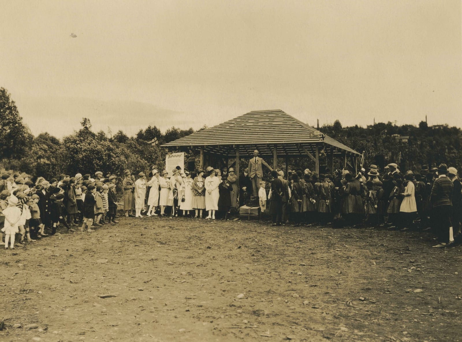
In 1909, at the peak of Burnaby's land boom, developers platted the Capitol Hill subdivision across these slopes. Streets were surveyed, lots were sold, fortunes were promised. Then the boom collapsed. By 1914, buyers had stopped paying property taxes. The land reverted to municipal ownership, and the grand plans dissolved into grass and scrub.
What happened next is the kind of story that rarely gets recorded. In 1922, Burnaby Council set aside 26 acres for future park use. But it was a local women's group that actually made it happen, raising funds, enlisting residents and businesses, building a playground with their own hands on the abandoned lots. The children who played there probably never knew they were playing on a real estate failure.
The park was officially dedicated on June 25, 1927, named for the Diamond Jubilee of Confederation. At its centre today stands the North Burnaby Cenotaph, a heritage-designated monument built in 1953 by Walter Holmes Morrice, stonemason, immigrant, and World War I veteran, for North Burnaby Legion Post #148. Bronze plaques list the fallen from two World Wars and the Korean Conflict. Legion volunteers still maintain it. Every November 11th, people gather here to remember.

But walk north, past the sports complex, and the park changes. The manicured fields give way to forest. Trails wind through steep terrain toward views of Burrard Inlet. Old nurse stumps, the remnants of fallen trees that once supported new growth, remain visible along the Confederation Nature Trail. An unofficial path crosses the railway tracks to reach the shore. It feels like a different park entirely.
And then there's the train.
Since 1993, the Burnaby Central Railway has operated on the park's north end, a 1/8-scale miniature railway run by the BC Society of Model Engineers, an organization founded in 1929. The railway was built with an estimated 40,000 volunteer hours. The landscaping beneath it came from 8,000 truckloads of fill excavated during the Cassiar Tunnel construction. Today the track stretches over 12,500 feet, with more than 70 switches, tunnels, and bridges. In 2018, they added a Garden Railway, now one of the largest Gauge 1 layouts in Greater Vancouver.
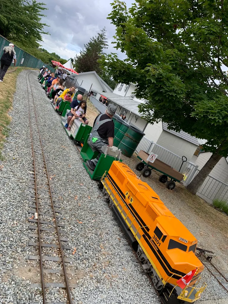
Stand at the north end of Confederation Park and you can see all of it at once: the cenotaph honouring the dead, the miniature railway built by hobbyists, the forest trails leading to the water, the sports fields full of children. It's four or five parks layered on top of each other, each one holding a different piece of the city's memory.
Getting there: 250 Willingdon Avenue. The forested trails and miniature railway are on the north side, away from the main sports complex.
The councillor nobody remembers
Stride Avenue Park sits next to Stride Avenue Community School in the Edmonds neighbourhood. There are no interpretive signs. No plaques explaining the name. Just a modest green space where children play and families gather, named after a street named after a man almost no one has heard of.
His name was Eber Stride, and he served on Burnaby Council from 1894 to 1913.
Think about those dates for a moment. Burnaby was incorporated in 1892. Stride joined the council two years later and stayed for nineteen years, through the pre-war economic boom that spiked the population from a few hundred to around 14,000. He served during the crucial period when Burnaby transformed from scattered farms and logging operations into a functioning municipality with roads, schools, and services. The Heritage Burnaby database offers one dry line: "The Stride Avenue School takes its name from the street which had been named after Eber Stride, Burnaby Councillor from 1894-1913."
That's all that remains of nineteen years of public service.
The Edmonds neighbourhood grew up around the interurban tramline connecting Vancouver and New Westminster, which began running in 1891. As Vancouver expanded, families moved east, looking for affordable land. Stride Avenue Community School opened in 1929 with just two classrooms. Additions came in 1949, 1953, 1957, 1964, 1969, and 1973 — a timeline that mirrors the neighbourhood's steady growth. Today the area remains working-class, family-oriented, home to waves of immigrants continuing patterns established in Burnaby's first decades.
The park is modest, a neighbourhood green space. Nearby are Poplar Park, Ernie Winch Park, the recently remediated Taylor Park. Together they form a network of accessible outdoor space across Edmonds, places where people can step outside and breathe.
Unlike the showpiece parks with their documented histories and heritage designations, Stride Avenue Park simply exists. A quiet tribute to the kind of work that keeps a city running, the committee meetings, the infrastructure votes, the slow accumulation of decisions that nobody celebrates. Eber Stride served for nineteen years. He got a street sign.
Finding what remains
These four parks share something essential: each one preserves what would otherwise be forgotten.
At Squint Lake, it's the memory of a beaver pond that real estate promoters tried to dress up with a fancy name, and the fact that local humour outlasted local development. At Taylor Park, it's the transformation of seventy years of garbage into a place where children dig for artifacts, where waste became wonder. At Confederation Park, it's the work of a women's group during a land bust, a cenotaph built by a veteran stonemason, and a miniature railway assembled through forty thousand hours of volunteer labour. At Stride Avenue, it's nineteen years of municipal service by a man whose contribution survives only on a street sign and a school.
Burnaby's heritage is not advertised. The Heritage Burnaby database at heritageburnaby.ca contains over 266 records tagged for parks, along with oral histories, photographs, and neighbourhood studies. The Burnaby Village Museum preserves artifacts across 31 buildings, including the 1923 War Memorial Fountain that once stood in front of Municipal Hall. The Charting Change Atlas offers an interactive map of the municipality from 1860 to 2011.
But the best way to find these stories is simpler. Pick a park you've never visited. Walk it slowly. Look for the nurse stumps and the sedimentary rocks, the cenotaphs and the sandboxes, the names on street signs that nobody explains.
You have to squint to see the stories.
More from February 2026
Full issue →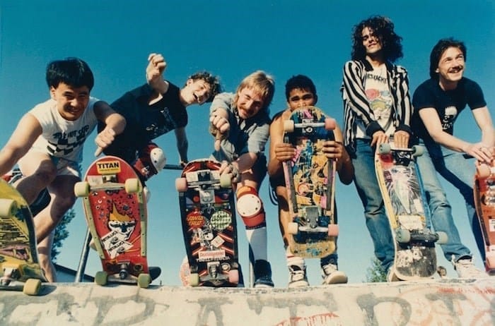
Burnaby's basement rebellion: How suburban teenagers built Vancouver's punk revolution
Canada's most influential punk scene wasn't born in gritty urban streets—it emerged from the split-level basements of Burnaby Mountain. How childhood friendships in a bedroom community produced D.O.A., The Subhumans, and the country's first indoor skatepark.
Artom Butenko · 17 min read
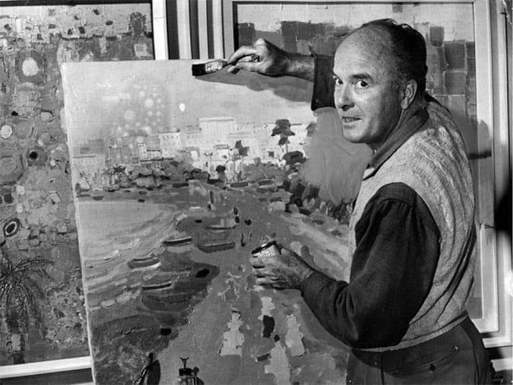
The Butterfly Painter of Capitol Hill: a story of Jack Shadbolt
For 48 years, Canada's most celebrated modern painter worked from a skylit studio on a Burnaby mountainside, transforming wartime trauma into butterflies and leaving behind the community arts centre that bears his name.
Brenda · 10 min read
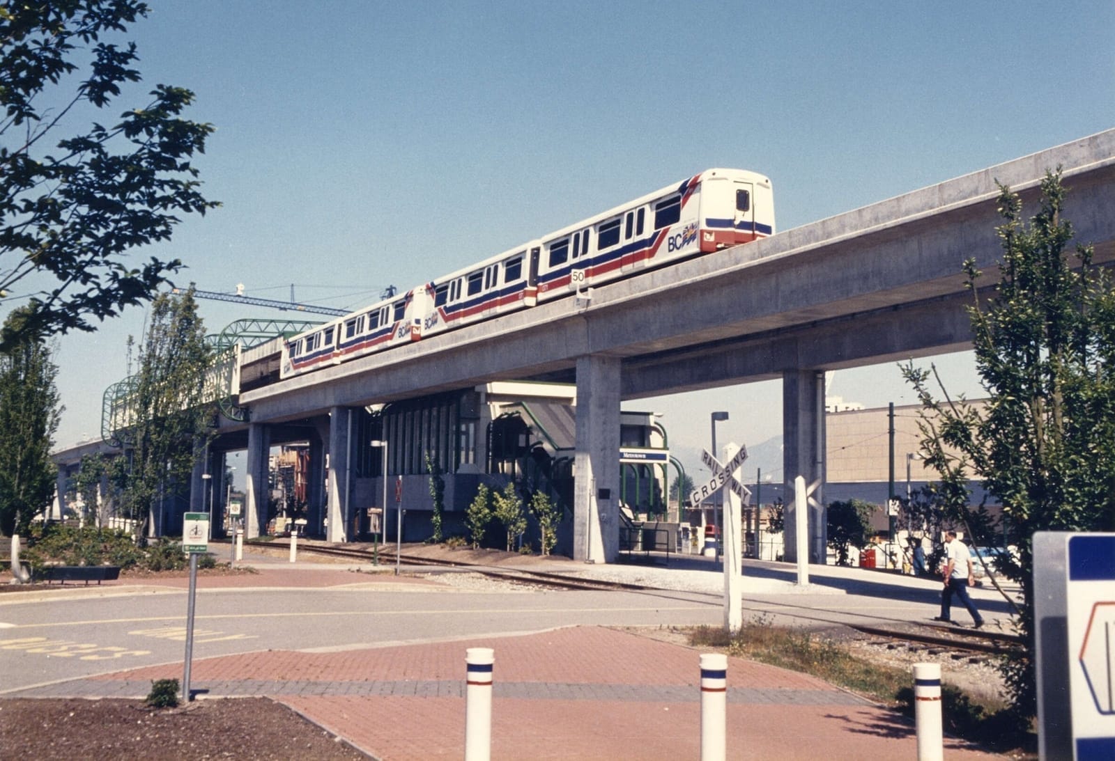
What Remains of Expo 86 in Burnaby
Forty years ago, a world's fair transformed Vancouver. But its true legacy isn't the pavilions or the fireworks. It's the concrete pillars carrying trains above Burnaby's streets every day. It's the route you may have taken this morning.
Artom Butenko · 10 min read